
1. Improving Atmospheric Models for Wildfire Smoke Transport in the Western U.S.
In 2018, 80.5% of the acres burned by wildfires in the United States were in the western U.S. This region is also experiencing an increase in the acres burned due to fire suppression management history, invasive species, increased human populations, and climate change; in 2003-2012 there was a 1,200% increase in acres burned compared to 1973-1982. These fires are hazardous to the people living near them, and the wildfire smoke also has public health consequences for populations downwind. The aim of this NSF-funded work is to use a transdisciplinary approach that integrates research related to wildfire smoke plume transport in an aim to improve our fundamental understanding of the wildfire smoke plume dynamics and complex atmospheric flows that govern smoke transport over mountainous terrain. The hypothesis is that the current models for vertical mixing in the atmosphere (atmospheric physics) and methods to estimate the vertical distribution of wildfire emissions (fire dynamics) cause significant biases in simulating air pollution concentrations (atmospheric chemistry) associated with wildfires in the western U.S. This research will transform our understanding of smoke transport in mountain-valley basins, and the outcomes include a forecasting model to protect human health by preventing and mitigating smoke exposure.
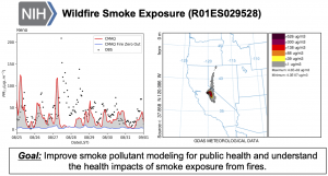
2. Modeling Wildfire Smoke Exposures in Nevada
Atmospheric models can be used to supplement the satellite data to simulate the wildfire smoke plumes in the western U.S and determine surface air pollution concentrations. We have a current NIH R01 led by Matthew Strickland (UNR) to investigate the health impacts of wildfire smoke in Reno. We develop the air quality and exposure modeling to estimate the wildfire smoke exposures for the epidemiology studies. This work combines chemical transport model results, satellite remote sensing, and atmospheric dispersion modeling to improve exposure metrics associated with smoke plumes in Reno, NV. In addition to modeling the smoke exposures, this project aims to improve the chemistry of wildfire smoke modeling by augmenting existing wildfire emissions estimates using data from burn chamber and ambient measurements collected by the Organic Analytical Laboratory at the Desert Research Institute (DRI) in Reno, NV.
3. Turbulent Mixing and Ambient Air Pollution Concentrations
Six years ago, we began investigating the impact of atmospheric stability on pollutant mixing and accumulation during wintertime. Specifically, stable atmospheric boundary layers are associated with a decrease in boundary layer height and inhibited mixing which causes an increase in pollutant concentrations. Using experimental data from the Salt Lake Valley in Utah, we investigated the impact of stable atmospheric boundary layers on atmospheric turbulence and pollutant accumulation during wintertime temperature inversions. We are modeling these air pollution events using numerical weather prediction (NWP) and chemical transport models. The goals of this research are to quantify the turbulent mixing during stable atmospheric conditions, especially during wintertime air pollution episodes in mountainous terrain using data from field experiments, perform sensitivity testing of NWP models to determine the bias in simulated surface fluxes compared to observations, and develop new turbulence parameterizations for the numerical models based on empirical data collected from field experiments in mountainous terrain with stable atmospheric conditions.
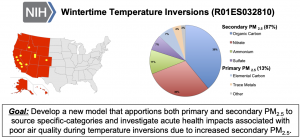
4. Atmospheric Chemistry During Wintertime Temperature Inversions
Wintertime inversions are a major driver of elevated air pollution concentrations for western U.S. cities located in mountainous terrain. To create effective regulations to protect human health in these and other western U.S. cities, it is necessary to understand the origin of the air pollution. Because the origin cannot be directly measured, source apportionment models are needed to trace pollutants back to their emission sources. Unfortunately, existing models cannot identify which source(s) to prioritize for mitigation strategies during temperature inversions because of the complex atmospheric chemistry and physics. We have an NIH R01 led by Heather Holmes to develop novel, innovative source apportionment models to identify the emissions that contribute to the elevated air pollution concentrations during wintertime and to determine their corresponding health impacts. The project is interdisciplinary and involves faculty from UNR, UC-Berkeley, University of Utah, and George Mason University.
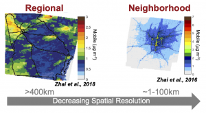
5. Models of Spatially Resolved Air Pollution for Exposure Estimates
Air pollution concentrations measured from regulatory monitoring networks are commonly used as air quality metrics in time-series epidemiologic analysis to investigate air quality and human health associations. While these data provide useful indicators for air pollution impacts in a region, the data are limited temporally, spatially, and chemically. With the growing availability of geocoded health data, spatially resolved exposure metrics are required for spatial epidemiological analyses. We use spatiotemporal air quality models and spatial source impact estimates to model exposure metrics for spatial health studies. We collaborate with faculty members from the University of Nevada, Reno (UNR) to develop exposure metrics for spatially resolved health effects studies using satellite remote sensing and air quality model results. We are currently working with Lyndsey Darrow (UNR) and Howard Chang (Emory University) on an NIH R01 to investigate the impact of extreme heat events on pregnancy.
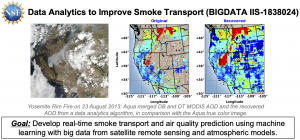
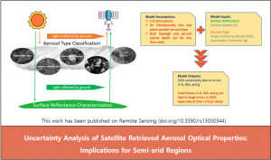
6. Satellite Remote Sensing of Aerosols
We use satellite retrievals of aerosol optical depth (AOD) to estimate surface particulate matter mass concentrations in the western U.S. The use of satellite retrievals in this region is not straightforward because of its complex topography and widespread presence of bright surfaces. Additionally, the presence of wildfire smoke plumes increases the uncertainty due to the presence of aerosols at multiple heights (e.g., fire plumes in the troposphere). Results from this NASA-funded work conclude that satellite retrievals in the Great Basin Region are unable to estimate columnar AOD when compared to ground-based AOD observations. Our current work is to develop new gap-filling algorithms for AOD retrievals and to estimate AOD uncertainties from satellite retrievals.
7. Utah Air Quality Forecasting
As part of an NSF CIVIC Innovation Challenge project, we are developing air quality forecasting products for the state of Utah. This work is part of a larger team project and is supported by a grant from NSF (2322009): Community Resilience through Engaging, Actionable, Timely, High-Resolution Air Quality Information (CREATE-AQI). You can read more about our forecasting products at the CREATE-AQI project website below.